Artificial intelligence challenges deforestation in Brazil
 Bruno Kelly/Amazônia Real from Manaus AM, Brasil Attribution 2.0 Generic (CC BY 2.0)
 The PrevisIA system uses artificial intelligence to rapidly analyze satellite imagery detecting critical variables that can promote deforestation. “Its predictive ability is fantastic,” according to its creators
by Matteo Cavallito
Is it possible to prevent deforestation using artificial intelligence? Yes, according to researchers at the Brazilian environmental nonprofit organization Imazon, which has developed a new system to intervene beforehand in areas at greatest risk.
The tool, called PevisIA, relies on the processing of images preempted by satellites, a notoriously crucial resource for this type of investigation. And it is allegedly able to identify areas prone to the phenomenon in advance by assessing a number of key variables. With success, according to some observers.
The Triunfo do Xingu case
In PrevisIA’s crosshairs this year, writes the British newspaper The Guardian, is the forest territory of Triunfo do Xingu, a protected area in the southeastern Brazilian Amazon in the state of Pará. Although formally protected by law, this area has long been subject to the development of illegal activities such as unauthorized mining, logging for the purpose of road construction, and general land grabbing.
“PrevisIA pinpointed Triunfo do Xingu as the Environmental Protection Area at highest risk of deforestation in 2023, with 271.52 sq km of forest in the conservation area expected to be lost by the end of the year,” the Guardian points out. “About 5 sq km had already been destroyed in March.”
These numbers may seem small but they are significant, especially in the current scenario. According to Imazon, in fact, deforestation tripled in March compared to the same month last year. In addition, 867 sq km of rainforest have been destroyed in the first quarter of 2023. That’s the second worst figure in 16 years.
Artificial intelligence as a law enforcement tool
Designed starting in 2016, PrevisIA was conceived to overcome old forecasting models capable of hypothesizing the dynamics of deforestation in the long term but not in the immediate future. To achieve this goal, the system works on two steps. First, it analyses trends in the region through historical data. Second, it studies variables that limit or encourage deforestation.
“Every month, Imazon uses satellite data to monitor deforestation in the Brazilian Amazon with the institution’s Deforestation Alert System,” explains Carlos Souza Jr., research associate and project coordinator.
“With this technology,” he adds, “forest degradation is made public, thus helping to raise awareness and understanding of biodiversity loss, carbon emissions, and the threat to indigenous people.” Moreover, “What if we could look to the future? What would happen if we could predict where the biome might be deforested? We would be able to avoid the forest overthrow. And this is why we have created a deforestation prediction model based on spatial statistics.”
The key evidence is road construction
Developed in collaboration with Microsoft and the investment fund Fundo Vale, the PrevisIA system is based on an algorithm capable of analyzing satellite images that once could only be observed, one at a time, by researchers themselves. Thanks to the computing power available, it is now possible to accomplish the task very quickly by detecting, among other things, the presence of a key indicator: namely, the tracks of “unofficial” roads under construction.
“Studies show that 95% of accumulated deforestation in the Amazon is located within a 5.5 km radius from roads,” Souza explains.
Quoted again by the Guardian, the coordinator called PrevisIA’s accuracy “fantastic,” pointing out that 85 percent of all reports of deforestation so far have occurred within a 4-kilometer radius of the intended location. Imazon has entered into official agreements with some state prosecutors’ offices in the region in the hope that using the system will more effectively prevent forest destruction.
 pxhere CC0 Public Domain Free for personal and commercial use No attribution required
 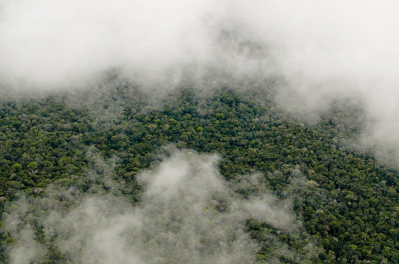 Photo: Neil Palmer/CIAT. Attribution-NonCommercial-NoDerivs 2.0 Generic (CC BY-NC-ND 2.0).
 Photo: Charbel El Khouri - International Center for Biosaline Agriculture, CC BY-SA 4.0

