A map of future roads helps fight deforestation
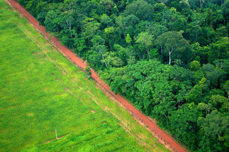 Kate Evans/CIFOR Attribution-NonCommercial-NoDerivs 2.0 Generic CC BY-NC-ND 2.0 Deed
 A team of Australian researchers managed to develop a deforestation risk index based on the probability that an area may be affected by new road construction
by Matteo Cavallito
In tropical areas, the construction of new roads is a particularly significant sign of subsequent deforestation. Unfortunately, many of these roads are not shown on official maps, making them difficult to identify. However, a new statistical indicator could help solve this problem, providing important support for administrators, activists, and decision-makers.
The proposal comes from researchers at James Cook University in Brisbane, Australia, who, in a study published in the journal Proceedings of the National Academy of Sciences (PNAS), described the new tool developed using a large data set. In this way, they explain, it was possible to identify the key environmental factors that determine the construction of new road sections.
25 million km of new roads by 2050
“Earth is experiencing an unprecedented wave of road building, with some 25 million kilometres of new paved roads expected by mid-century. Roughly 90% of all road construction is occurring in developing nations including many tropical and subtropical regions of exceptional biodiversity,” said Bill Laurance, professor at James Cook University and co-author of the study. “Mapping studies in the Brazilian Amazon, Asia-Pacific and elsewhere are regularly finding up to 13 times more road length than reported in government or road databases.”
In the tropics, the study notes, new routes are being opened at a rapid pace, especially in remote frontier areas. However, not all land is suitable for this purpose.
Road construction is strongly influenced by specific factors such as topographic slope and the chemical and physical properties of the soil. But it is also influenced by climate variables such as rainfall, socioeconomic factors such as population density and economic growth, and administrative aspects that affect the costs construction and maintenance. That said, “given that the ultimate causes of deforestation, such as mining, logging, and agriculture, are largely confined to areas suitable for road building, identifying the factors that allow road proliferation is a key priority.”
Distance from rivers, population density, and soil among the decisive factors
To do this, the researchers focused on three large regions: the Congo Basin, the Brazilian Amazon, and the Insular Asia-Pacific island region. Using existing global datasets, they mapped roads at a very precise resolution of 1 hectare, creating an overall representation consisting of 137 million raster cells. Raster cells are units of a digital map associated with a value that indicates a specific characteristic. In this case, the presence or absence of a road and other variables (slope, soil type, etc.).
For each cell, information was extracted on 44 biogeophysical, socioeconomic, and administrative variables potentially relevant to road construction.
Finally, using machine learning models, the authors estimated the probability of roads being present and identified the main factors related to their distribution. “The most influential covariates in the pantropical model were distance to river, population density, and topographic features such as slope and topographic roughness,” the study explains. “Soil characteristics such as silt and clay fraction were also highly important, as was rainfall seasonality.” In contrast, vegetation type appears to have a relatively minor influence.
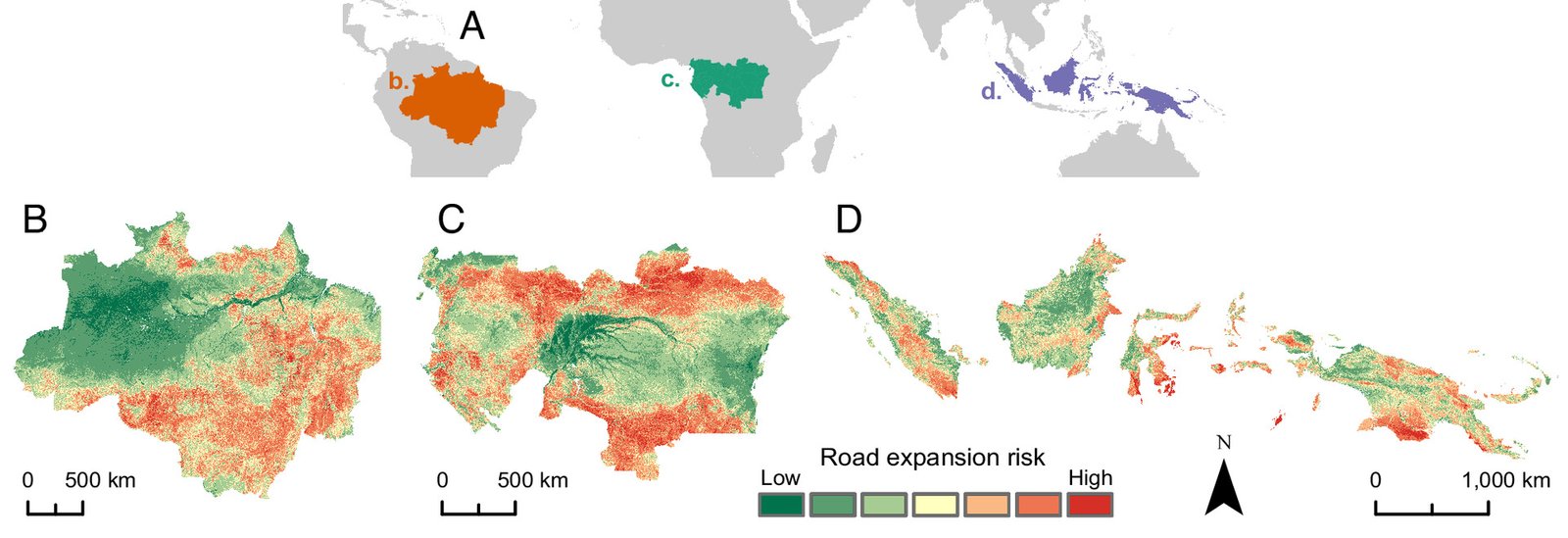
At a global level, the highest road expansion risk for the near future is in the Amazon and the Congo Basin. Source: Jayden E. Engert et al., “Road expansion risk predicts future hotspots of tropical deforestation”, December 22, 2025 122 (52) e2502426122 https://doi.org/10.1073/pnas.2502426122 Copyright © 2025 the Author(s). Published by Proceedings of the National Academy of Sciences (PNAS) Attribution 4.0 International CC BY 4.0 Deed
The Amazon and Congo Basin are the areas most at risk worldwide
Based on informations gathered, the authors then developed their road expansion risk index, based primarily on the suitability of the territory. The indicator represents the probability that an area may be affected by new road sections. The resulting maps show that the highest risk for the near future is in the Amazon and Congo Basin. In Asia-Pacific, some areas, such as Sumatra and eastern Kalimantan, could experience significant road expansion.
The study also identifies regions, such as the Guiana Shield, the vast forests of Congo, and much of New Guinea, which are still relatively intact but highly vulnerable to new infrastructure projects.
These areas, the authors write, “are of particular conservation concern as they are often the subjects of proposed future developments, including highways, development corridors, and major oil palm and wood-pulp projects and logging concession.”
A tool for predicting deforestation and more
The researchers conclude that the indicator is an excellent predictor of deforestation and forest degradation with a high degree of accuracy. It is therefore a useful tool for planning, conservation, and strengthening protection policies, particularly in protected areas and indigenous territories. And there’s more.
Since roads are also vectors for the spread of human pathogens, Laurance notes that the index could also “help identify zones prone to zoonotic spillover – where diseases jump from animals to humans.”
The index also help to identify “potential invasion routes for exotic weeds and feral animals, which thrive along disturbed roadways.” This resource can be used in many ways and could transform conservation strategies, enabling governments, NGOs, and international organizations to take timely action in the most vulnerable tropical areas.
 Jonathan Wilkins Attribution-ShareAlike 3.0 Unported CC BY-SA 3.0 Deed
  Melissa McMasters Attribution 2.0 Generic CC BY 2.0 Deed

